Experimental p-coding site
This site contains GeoJson files with names matching UNHCR p-codes (place codes) for administrative units. All geographic files hosted in GitHub and managed under version control. This site is based on an idea from the Open Knowledge Institute and is forked from a test from the Humanitarian Exchange Language (HXL) team
Parameters
- {COUNTRY}
- An ISO 3166-1 alpha3 code for the country, e.g. "JOR" for Jordan.
- {admin-level}
- The requested admin-level (ADM1, ADM2, ADM3, ADM4) for the country.
- {TYPE}
- geoJson present boundaries using [multi]polygon.
Example
Download the GeoJSON polygon for admin level 1 of Jordan (Governorates):
https://github.com/unhcr-mena/p-codes/blob/gh-pages/geojson/JOR/ADM1.geojson
Usage
The files use the following naming scheme: https://unhcr-mena.github.io/p-codes/geojson/{COUNTRY}/{admin-level}.geojson
The geoJSON map can also be placed in any HTML page that supports javascript (e.g., GitHub Pages) and embedded within an Iframe. For example, for Jordan, the URL to the raw file is accessible @ https://raw.githubusercontent.com/unhcr-mena/p-codes/gh-pages/geojson/JOR/ADM1.geojson .
By default, the embedded map size from https://render.githubusercontent.com/view/geojson?url=https://raw.githubusercontent.com/unhcr-mena/p-codes/gh-pages/geojson/JOR/ADM1.geojson is 420px x 620px, but you can customize the output by passing height and width variables as parameters at the end, such as height=300&width=500.
GeoJson is also supported by multiple softwares. With ArcGIS, you can use ArcMap's Data Interoperability tools or this tool. You can also use ArcGIS online from ESRI
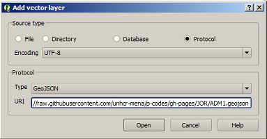
With Qgis. 
With R statistical software and use the SP library library("sp"); url <- "https://raw.githubusercontent.com/unhcr-mena/p-codes/gh-pages/geojson/JOR/ADM1.geojson"; out <- geojson_read(url, verbose = FALSE); plot(out);
In addition a pcode reference file, itemsets.csv, is available for each country. This reference file can be used when creating Cascading selects geographic questions using the select_one_external function within XLSFORM questionnaires. The itemsets.csv file can be uploaded to UNHCR Kobo Server as a media file. It will be downloaded to any Kobo Collect like any other media file and saved to the [form-filename]-media folder. Clients like Kobo Collect load media files from the SD card and so a field data collection form with all locations within the country can load very quickly.
Disclaimer
The designations employed and the presentation of the material on this map do not imply the expression of any opinion whatsoever on the part of the United Nations concerning the legal status of any country, territory, city or area or of its authorities, or concerning the delimitation of its frontiers or boundaries. Every effort is made to ensure this map is free of errors but there is no warrant the map or its features are either spatially or temporally accurate or fit for a particular use. This map is provided without any warranty of any kind whatsoever, either express or implied.
Schema
The schema is designed to allow for mapping of various thematic dataset. Unique ID from various systems are included.
- gid: Unique ID for this dataset
- name : Admin Unit name
- namealt : Admin Unit alternative name
- namear : Admin Unit name in Arabic
- namearalt : Admin Unit alternative name in Arabic
- iso3 : Country Code ISO3
- idprogres : ID for UNHCR proGres refugee registration system
- idfocus : ID for UNHCR Focus system
- idocha : ID for OCHA Common Operational Dataset
- idgaul : ID for FAO GAUL - Global Administrative Unit Database
- idnatural: ID for Natural Earth
- idicrc : ID for ICRC
Maintain
The files are text based and can be maintained directly in Github.
Files can be then edited through a regular GIS software or directly through in a an online editor like GEOJSON.io.
The present repo can be forked and pull request can be submitted if files have changed.